Siachen world’s only nuclear triangle
Guns kept blazing every day from that day till 2003 when India and Pakistan agreed on a truce. Significantly, Siachen sits on the nuclear tri-junction of India, Pakistan and China. It’s the world’s only nuclear triangle.
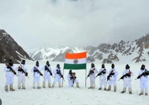 Siachen: April 13 is an important milestone in global military history as India dramatically took decisive control over the Siachen glacier in the Himalayas on that day 40 years ago in 1984. It symbolises the gritty and determined deployment of the armed forces at the highest battlefield in the world – 20,000 ft above mean sea level – to protect the frontier despite heavy loss of human lives. Guns kept blazing every day from that day till 2003 when India and Pakistan agreed on a truce. Significantly, Siachen sits on the nuclear tri-junction of India, Pakistan and China. It’s the world’s only nuclear triangle.
Trouble began with the drawing up of a UN-brokered India-Pakistan ceasefire line in 1949 following the first war. The subsequent Karachi accord that year left the job of boundary delineation incomplete. The mutually accepted line was drawn only up to NJ 9842, which is the grid coordinates. From there, it said “thence north to the glaciers”.
Drawing the line straight north didn’t make sense as it would have cut through the glacier, frigid and icy rivers with changing contours and crevasses (deep crack in a very thick layer of ice) where deployment of forces and border patrol would anyway be difficult.
The correct interpretation of the ‘thence north’ phrase was to follow the natural features, which meant extending the line right up to the Indira Col along the Saltoro Ridge towards the west. That’s India’s position (see map). But Pakistan sought to twist it to mean it went further towards the northeast and terminated at the Karakoram pass. That interpretation would have swallowed the Siachen, which is the source of freshwater for the Indus river and much more.
Pakistan tried all its dirty tricks to snatch the glacier, even fighting an unprovoked war in Kargil in 1999 to sever Indian access to the Siachen. The glacier has strategic significance because Pakistan’s all-weather friend China is perched on the other side of Siachen, prepared as it is for the long haul. To illegally construct the China Pakistan Economic Corridor (CPEC) in Pakistan Occupied Kashmir (POK) in Gilgit-Baltistan, Beijing has deployed engineers of the People’s Liberation Army (PLA) and personnel of other construction companies there. Besides, China has moved in more than 60,000 heavily armed troops from Demchok up to Depsang in Eastern Ladakh along the Line of Actual Control (LAC) with India. The Chinese troop buildup is not very far from Siachen.
The word Siachen is an amalgamation of Sia and Chin, which in the local Balti language means place of roses. Wild rose shrubs can be seen at the snout of the glacier and in the lower valleys. Roses may symbolise peace and love, but bilateral frost is all you get at the glacier.
The Siachen glacier is 76 km long while its width varies between 2 km and 8 km as it juts into Gilgit-Baltistan. The glacier hangs at the snout towards OP Baba with Indira Col (named by the Workman expedition after goddess Laxmi, one of whose many names is Indira. The nomenclature has nothing to do with the then PM Indira Gandhi) at the northernmost point of the Saltoro Ridge.
With the changing international dynamics, the ground situation at the glacier acquired added significance because of its unique location. Growing military ties between China and Pakistan brought to India the very real challenge of a possible ‘two-front war’.

Comments are closed.